Friday, May 31
Testing 1, 2, 3
Please bare with me as I am troubleshooting our blog. It has been brought to my attention that followers haven't been getting the latest posts. Please e-mail us if you get this post. Your help is greatly appreciated.
How many cruisers does it take.....
Welcome to Clarence Town! Located on Long Island, Bahamas. It was an overnight sail from Great Inagua Island. The wind was not in our favor, forcing us to sail close hauled. Our boat does not sail at its best that close to the wind. As we neared the northern tip of Great Inagua Island, the waves really wrapped around and we were taking a beating. Badly. Even Patronus, who stayed closer to shore, said we looked like a cork bobbing up and down. At one point, we nearly turned around and to wait until we had a better wind angle. But Chris, the ever positive sailor, encouraged us to go a little further, thinking the wind would clock around and the waves would settle down. Well, the waves were less confused and blew from a more consistent angle. However, that angle wasn't quite as we'd hoped. Our weather router was a little off on the forecast that day. Oh well, we made it in one piece, slowly but surely.


The following day, we looked it up and asked around and learned it was just a short drive north of our anchorage. Ohhh, okay. So, we rented a mini, mini-van barely big enough for the 10 of us. In fact it was so small, the kids were piled where ever they would fit which made for some testy tempers. But that's beside the point. We found the road that lead us to Deans Blue Hole, made one more wrong turn before finally parking the car. We were all sort of grumbling that this better be good after all we had been through just trying to find the darn thing.


Just in case you were wondering if you could get any livestock in Clarence Town...the answer would be yes! Of course, it says so on the sign.

The pounding surf, at hight tide, just in front of where we anchored in the reef protected cove of Clarence Town. When the tide was high, the current was super strong. The current was so strong that our swim ladders were nearly parallel with the waters surface.

There were 4 sailboats and Foxy Lady

The marina where we landed our dinghies....very friendly, helpful staff

Is this Deans Blue Hole?
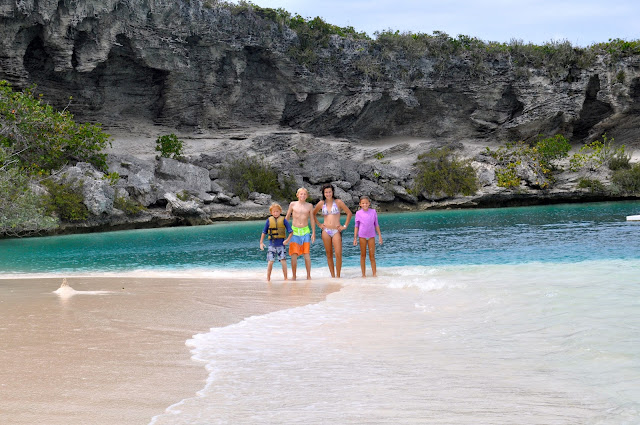
How many cruisers does it take to find Dean's Blue Hole?? Ummmm, 4 adults, 2 dinghies and a rental car with 6 kids in tow. I was the one who suggested we skip the Crooked Islands and go straight to Long Island based on what I had seen on s/v Por Dos' website. The things they had seen and done looked so much more interesting than visiting some islands that we knew very little about (they were uninhabitated). Why not? When looking at the chart, we tried to locate Dean's Blue Hole but it wasn't labeled. However, there was a big, perfect circle on the chart very close to where we were anchored. That must be it? But why did it say it was only 30 feet deep? That's strange. Without thinking twice, without asking a single question, we set off in the dinghies across some shallow water to the 'big blue hole'. It looked so amazing to see super shallow, incredibly light blue water turn a deep blue instantly. That must be it. But wait, that couldn't have been it because it looked nothing like the photos in Por Dos' post. I suggested that we walk over to some more super shallow water around the bend and maybe it will be there. I went ahead and thought I had finally found Deans Blue Hole. Except that it wasn't very deep blue. It was more like a dark green, reminiscent of 20 feet in depth, not the 600 feet it was supposed to be. Erica donned her snorkel mask and set out to see if we could come to some sort of conclusion once and for all. Nope, that was definitely not it. Hmmmm, well it must be the big blue spot over there. So, we traipsed back to the other 'hole'. We all got our snorkel gear on and swam out to the middle. The water was so warm right at the edge but as soon as we swam into the deep blue, it felt 10 degrees colder...brrr. It must be way out there in the middle where the bouy is. We thought, of course, that's where they do the free dive courses. Wrong, again. It was 30 ft deep just like the chart said. We swam back to the dinghies, let the kids play on the beach while we scratched our heads trying to figure out where we went wrong.

Oh, there's the sign...clear as mud sitting on the ground with overgrown bushes in front of it.

And then we were met with this sign....what would you be thinking?

That's the real platform used for free diving classes (which we tried to arrange but the company had left for the season).
Ahhhh, finally. Deans Blue Hole. Now this is what I remember from the pictures! It looks inviting and mysterious. Its deep blue color is mesmerizing as you stare at the seemingly infinite depth. Deans Blue Hole is the worlds deepest known blue hole and the worlds second largest, water filled cavern body. We put on our snorkel gear and checked it out for ourselves. I was nervous. I don't know why. Perhaps I thought the blue hole would swallow me. It took me several tries to feel comfortable diving down to where the hole was located. It was clear as day. The sandy edge gently sloped 30 feet or so and then it just dropped, 660 feet! The hole itself was roughly 100 feet wide. We snorkeled around the perimeter, watching the fish and a group of baby sea horses. We also jumped from the rocks with no worries about hitting bottom!


The beautiful shallow waters right next to the blue hole

The ragged, weather worn rocks surround the blue hole

After all that searching, we were starved. We found Max's along the roadside and it looked like it had a lot of stories to tell.

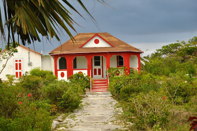
Bahamian house behind Max's.


See what I mean...so much to look at. I ordered conch salad which was made fresh right there on the spot. I even got to test my batch to make sure it wasn't too spicy.

After lunch, we headed back to town. We stopped at Sts. Peter and Paul Catholic Church. This is one of two churches in town built by the same man.

View of Clarence Town and the anchorage from the top of the church turret. You can barely make out 5 little specs across the water. One of those is our boat.

Looking the other direction

Princesses awaiting their prince charming

Peek-a-Boo

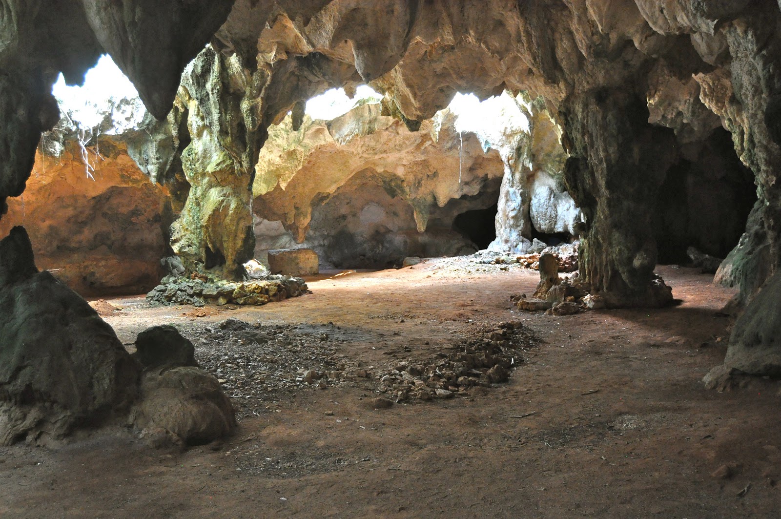
We had an appointment at 10 am the next day to tour Hamiltons Cave.

Entering the cave with our guide, Edward. His family owns the property in which these caves lie underground. They were once used by the Lucayan Indians as well as a hurricane shelter in more recent years.

Tree roots reaching for the ground from above the cave

Stalactites dripping from the limestone ceiling of the cave.

Stalagmites forming from the stalactites above
Columns form where stalactites and stalagmites meet

Another beautiful stalactite that has been forming for hundreds of years and is laden with crystals that sparkle in the flashlight beams.

Spies or cave dwellers?

One of the 5 species of bats that call the cave home. The bat droppings used to be shoveled out and used as fertilizer. Some people in our group, to be left nameless, did not like the bats!

One of the ancient sculptures carved into the limestone

Ancient carvings on the limestone walls

The whole gang
Thursday, May 30
Land Ho...Great Inagua, Bahamas
We made it! We arrived in Great Inagua, Bahamas as the sun was rising at 6:30 am. on Thursday, April 25th. We had a great passage with the exception of a broken hatch. On the second day of our passage, the wind was still blowing at 20 knots from our stern. The sails were set in the wing on wing position (the jib on one side and the main on the other). We use a preventer (line tied from the sail to a cleat) so that if the wind changes slightly, the sail doesn't accidentally gybe on its own. The wind had shifted just enough that we didn't need to be wing on wing anymore. Craig went out on deck and removed the preventer so he could put the jib back on the other side. Every other time we did this maneuver, we bring the bow of the boat into the wind a little, pull the jib sheet in so that it flips to the other side with minimal force. On this particular day, Craig did not wait for the boat to come into the wind. Instead, he man handled the sail with all his might and as soon as the wind got a hold of the sail, it whipped to the other side. That in and of itself is bad for the sail and the rigging, but that is not the worst of the story. Craig happened to be holding the jib sheet at the time and didn't let go. In his mind, he was going to gently let the sheet out, protecting it from harm. What he forgot was that 20 knots of wind packs a big punch! Let me just say that all I saw from the helm was 2 bare feet flying clear across the deck...all 21 feet! The power of the jib whipping to the other side sent Craig flying. Luckily, he had a good grip. Unfortunately, he landed on our bathroom hatch and cracked it in 3 places. He sliced his baby toe in the process. It was a moment of panic and mixed emotions...."are you okay?!"...."what were you thinking?!" I thought for sure he had broken a couple of ribs or knocked his head on something. I was thankful that he stopped at the hatch and didn't continue overboard. That would have been a bad way to end the day.


The island of Great Inagua is flat as flat can be and very barren. We didn't see the island as we approached in the boat until we were right up next to it. That was a very different experience than the Caribbean Islands, that are so mountainous.

Craig trying to go into town to check in to the Bahamas, but there was quite a road block in the way. The mail boat was there dropping off supplies, pretty much blocking the entire entrance to the harbor. The inlet was just wide enough for one boat a time. He eventually tied up to a derelict, abandoned fishing boat that we later learned was confiscated for drug trafficking.

The cruising guide said the the harbor was only big enough to accommodate a few boats at a time. Truth be told, the 'harbor' was less than ideal with no room for any boats other than the various fishing boats half sunk in the middle of the harbor or sunk tied to the dock. To call it a tight squeeze would be an understatement. Now we knew why the mail boat was sticking out the narrow inlet.

Lots of room for Anything Goes in the many shades of blue

As we anchored that morning, we thought it was so cool these 'local' guys were coming back in from a fishing trip. Later, at the same time we found out about the drug boats, we found out these were Haitians sailing 90 miles fromm Haiti for "supplies". Let me tell you that these were some salty dogs if I ever saw some. The masts to their boats were literally made from tree trunks and the sails were patch work at best. This one picture above was one of the nicer, well kept boats. But as we looked closer (from the dock where they were tied up) we could tell that they had just the shirts on their backs, no life jackets, no emergency EPIRB, no electronics (chart plotter, VHF radio etc). and no lights. And they sailed at night! Crazy scary if you ask me. We learned from the park warden that the Bahamas spends over 2 million dollars a year sending Haitians back to Haiti from various Bahama Islands and surrounding waters. Some of these sailboats are found carrying as many as 260 Haitians trying to escape. Imagine 260 men, women and children on the boat pictured above!

Craig met the parks warden, Henry, the day he went into town to check us into the Bahamas. Henry gave him a lift to the government office. The following day, we all rode in Henry's truck as he gave us a tour of the Morton Salt Companies Sea Salt salt ponds, manufacturing facility and the Inagua National Park.
Pictured above is one of the many salt pans during one of the 3 different stages of evaporation, leaving salt around the edges. The white 'snow' looking stuff is really salt.

Driving on the road with salt pans on either side


Crackling sand/mud where the fresh water has evaporated from the edge. It looks hard and crusty but Henry told us we'd sink to our knees!

Flamingo in flight

Flamingoes prefer the fresh water. The flamingo is the Bahamas national bird and there are some 80,000 of them.

Taking flight as Henry's diesel truck drives by

Morton's Salt Company "salt dock". The salt is transported from the island to a container ship via this conveyer system.

Along the way, we stop so the kids can pick some wild cotton. Cotton used to be the cash crop here in the Bahamas way back when slavery was allowed.

Mountains of sea salt

This would be the 3rd stage; harvesting the salt. The Bahamas are Morton's biggest facility in the world, producing 1.3 million tons of sea salt per year!

If you didn't know better, you'd think I put a picture of the midwest snow here. But it's not, it's salt that has drifted and collected on branches sicking out of the shallow (pink) water. The salt gives the water a pink hue. Can you see it?

Walking on the salt flats. So fun to see it in it's natural state. Don't worry, they wash the salt with a salt brine before packaging it up and selling it to the masses.

The sea water is pumped through a 5 mile long canal into the various salt ponds.

Matthew Town Lighthouse. It used to be 1 of 4 in the world that still was hand cranked and lit with kerosene. It was recently converted to a modern LED light.

Shadow of the lighthouse at the waters edge

The spiral staircase leading to the tippy top

View from the top

The motley crew

Like a rainbow!
Subscribe to:
Posts (Atom)